v6.1 [Mar 1, 2008]
- Fixed some map display issues (22s & 71s labels instead of highway names).
- Fixed Pedestrian routing.
- Fixed some other routing issues.
- Fixed Find Nearest Waypoints issue.
- Fixed vertical profile custom scale settings (right-clicking on the scale of the vertical profile).
- Fixed selection issue (waypoints were not de-selected when selecting a track before).
- Fixed an issue where MapSource did not remember the grid setting correctly.
- Fixed an issue with the updating process.
- Fixed sort by number of via points in the route tab.
- Fixed an issue with spot soundings.
- Fixed a Polish localization issue.
- Made MapSource more robust when encountering invalid map products.
- Improved handling of invalid gpx files from devices.
- Improved handling of missing components, MapSource will now display a message indicating the missing component.
- Changed number of most recently used files from 4 to 10.
- Fixed some untranslated strings.
- Fixed an issue with saving as gpx and dxf in the Dutch localization.
- Fixed a routing issue with third party map products.
- Fixed several other routing issues.
- Fixed an issue where MapSource would not remember the icon size setting correctly.
- Fixed an issue with deleting waypoints from a route.
- Fixed a map drawing issue.
- Fixed display of ampersands on the map.
- Fixed an issue with creating waypoints on certain features.
- Added support for 64-bit USB device drivers.
- Added generic label descriptions (less 'unknown' features).
- Added support for importing relevant data from TCX files.
- Added very small and very large symbol size selection.
- Added support for editing waypoint address and phone number information.
- Added New Zealand TM grid.
- Added display of the total length of all selected tracks/routes in the status bar.
- Added numeric sorting of routes, tracks and waypoints.
- Added ability to send error reports directly to Garmin after a crash.
- Improved memory issues when running MapSource under Windows 7.
- Improved map projection for many map products.
- Improved speed of 'finalizing' step when transferring data to SD cards.
- Changed mouse-wheel functionality to zoom in and out.
- Changed 'seasonal closures' avoidance option to 'date and time closures'. MapSource will now route over roads that have time-of-day and seasonal closures if this avoidance option is not checked.
- Changed route via point symbol to small black dot.
- Fixed various categories and subcategories that affected find operations and the display of POI categories and subcategories.
- Fixed some auto-routing oddities.
- Fixed remembering 'Find Nearest' dialog search category.
- Fixed issues with 'Save As' file dialog (in some cases, existing files were overwritten without prompting).
- Fixed some issues with the Swedish grid.
- Fixed issue with address search when a city name was supplied.
- Fixed loss of mixed-case characters when transferring routes to some USB devices.
- Fixed an issue with the refreshing of the route avoidances dialog.
- Fixed an issue with finding elevation features.
- Fixed an issue where the comment field would be incorrect after creating a waypoint from a find result.
- Fixed an issue where transferring data from a mass-storage device would fail.
- Improved performance for custom draw elements.
- Made sure waypoints of type 'Geotagged Photo' don't crash MapSource.
- Allowed the import and export of unlock codes.
- Made sure unlocking changes get propagated without needing to restart the application.
- Phone numbers that were imported from gpx files were not written back out again. This is now fixed.
- Added support for enhanced map security.
- Fixed unlocking issue.
- Implemented Asian 6-level address search.
- Improved trimming performance for some Asian map products.
- Fixed an issue where maps could not be transferred on certain non-English Windows installations.
- Reduced size of symbols when configured to use small symbols.
- Fixed an issue finding campgrounds on some newer map products.
- Fixed an issue with the file save dialog when the file extension field is hidden.
- Fixed an issue where MapSource would crash if the route avoidance dialog would be displayed twice.
- Fixed waypoint category filter issue. Now only waypoints of the selected category will be displayed.
- Fixed waypoint prefixes.
- Fixed an issue where MapSource would crash with certain address searches.
- Fixed memory leaks in the waypoint dialog and map rendering.
- Fixed an issue with saving gpx files when the file path contains Asian characters.
- Fixed some hotkey issues.
- Fixed an issue with searching for certain POIs.
- Fixed an issue with how unlock codes were stored that caused incompatibilities with applications like Training Center.
- Support Web Link Extensions in Brazilian Portuguese.
- Changed waypoint image size to follow the user selected symbol size.
- Fixed an issue using custom waypoint symbols installed in the current user directory.
- Fixed an issue displaying the vertical profile for certain maps.
- Fixed route issues for routes containing a waypoint more than once.
- Fixed transfer from and to Garmin Mobile PC devices.
- Fixed an issue with opening gdb files containing routes with identical names.
- Fixed an issue where the 'anchor' waypoint symbol was displayed incorrectly.
- Fixed an issue with map scrolling.
- Fixed an issue with route travel time calculations.
- Fixed an issue with performing address searches.
- Fixed an issue displaying map labels in print preview.
- Fixed an issue where blank map tiles are left on the screen.
- Fixed an issue with redrawing the map after a detail level change.
- Enhanced the drawing of roads to better distinguish primary from secondary roads.
- Added the ability to adjust symbol size of icons.
- Fixed the display of spot soundings in Marine maps.
- Fixed an issue with areas getting highlighted inadvertently.
- Fixed 'Move Waypoint', 'Insert Route Section', and 'Extend Route' capabilities from right-click context menus.
- Fixed an issue with water regions getting clipped.
- Limited 'Nearest Features' to only displayed maps.
- Fixed overlapping copyright information for certain maps.
- Fixed the display of certain Marine icons in the 'Find Nearest Places' dialog.
- Fixed an issue with improper amenities getting displayed for 'Exit Properties'
- Modified the color used for bathymetric lines.
- Enhanced the look of dashed and dotted lines.
- Enhanced sizes of certain labels.
- Enhanced the look of road shield icons.
- Fixed an issue when using certain find operations.
- Fixed an issue where changing the font would result in no labels being displayed.
- Fixed an issue with using the Roads & Rec 2.1 Hawaii and Alaska product
- Updated map rendering to provide visual improvements.
- Added support for U.S. National and Swedish SWREF99 grids.
- Fixed issue with setting the PC clock on Vista.
- Allowed user specified colors for routes.
- Added Brazilian Portuguese translation.
- Improved interface for managing map products and unlock codes.
- Fixed an issue sending maps to units on Asian language computers.
- Fixed an issue where the vertical profile was not displayed correctly.
- Fixed an issue when transferring data to a blank SD card.
- Fixed an issue where the map tile name was not displayed correctly on the unit after transferring to the device with MapSource.
- Fixed error when displaying feature properties on some map products.
- Display find results from base map.
- Correct localization issues for some languages.
- Fixed announcing of extra via points on some USB units
- Fixed incorrect waypoint names when exporting point to point routes
- Fixed incorrect display of Asian language labels
- Fixed incorrect import of user data in Asian languages
- Fixed recognition of SD cards initialized in a marine unit
- Fixed an issue with displaying the product name of some map products.
- Fixed an issue with receiving data from removable media on Windows Vista 64-bit.
- Fixed an issue with receiving the unit ID from the Symbian version of Garmin Mobile XT.
- Fixed various Asian language localization issues.
- Fixed an issue with the 'View in Google Earth' feature.
- Fixed an issue with viewing maps around the antimeridian.
- Increased the maximum search radius of the 'Find Nearest Places' dialog.
- Improved the View in Google Earth feature.
- Improved the Find Nearest Places dialog.
- Improved the transfer of user data to removable media drives for marine units.
- Added support for transferring user data to Symbian Garmin Mobile XT devices.
- Added a temperature field to the tab delimited text output.
- Fixed an issue where a track or route vertical profile that spanned a detailed map boundary had an erroneous fissure on the plot.
- Fixed an issue with URIs (links) in GPX files that contain non-ASCII characters.
- Fixed an issue when opening a GPX file that contains a new-line as the first character of a waypoint comment.
- Fixed an issue with adding duplicate link entries in the waypoint dialog.
- Fixed an issue with rendering maps in a locked map product that contains terrain shading data.
- Fixed an issue detecting some Garmin mass storage devices.
- Fixed an issue at application startup when the expected code pages are not installed on the PC.
- Fixed a layout issue in the Czech language waypoint dialog.
- Fixed an issue transferring routes to the Zumo.
- Fixed an issue with the integration of Google Earth and MapSource.
- Fixed an issue with the size estimate of selected map sets.
- Changed the default file format to GDB version 3.
- Added web links. This feature allows user created internet search options to appear on context menus. These search options can use either location or name information.
- Added a MiniMap.
- Added new waypoint symbols (contacts, geocache, hunting, etc.).
- Added support for multiple links on waypoints, routes, and tracks.
- Added additional guidance for the user when clicking on the 'View in Google Earth' menu item.
- Added support for writing waypoints, routes, and tracks to SD cards for new chart plotters.
- Enhanced the driving directions page in the route dialog to provide additional statistics.
- Added a notes area to the route dialog. These notes are printed with driving directions.
- Added two options to the routing preference 'Try to Avoid' list: ferries and seasonal road closures.
- Added support for multi-line comments for waypoints.
- Added a transfer preference to specify if (and which) serial ports should be searched for Garmin devices. This should solve problems for users that have badly behaved internal modems that cause MapSource to hang.
- Added the ability to join tracks from the Tracks page.
- Added track color to the list on the Tracks page.
- Changed the behavior of the track draw tool to populate the elevation in tracks if the map product has DEM elevation data.
- Changed several feature symbols (mountain peak, city, and airport) to be smaller so they don't obscure as much of the map. This only applies when the large symbol size is selected.
- Adjusted the layout of several preference pages for improved usability.
- Changed the behavior of several dialogs to ignore the degree symbol in user provided coordinate strings.
- Fixed an issue when selecting map sets larger than 4 GB in size.
- Fixed an issue with saving files to offline network drives.
- Fixed an issue with preserving line feeds inside of comments in GPX files.
- Fixed an issue with printing when the 'No Map' product is selected.
- Fixed some line rendering issues on Blue Chart map products.
- Fixed an issue with some postal code address searches not finding results.
- This version of MapSource no longer supports Windows 98, Windows ME, and Windows NT.
- Fixed an issue with transferring map sets larger than 2 GB to units. MapSource supports transferring map sets up to 4 GB in size. Note that some units do not support map sets over 2 GB in size.
- Fixed an issue with creating a waypoint from Japanese address search result.
- Fixed an issue with MapSource not finding Google Earth Pro when installed.
- Fixed some translation issues.
- Fixed an issue with searching for marinas in NT map products.
- Fixed an issue when receiving GPX files that contain waypoints with phone numbers from Garmin mass storage devices, such as the Nuvi.
- Fixed an issue with some devices not turning off after transfers.
- Fixed an issue with route driving directions having the wrong direction in the street/highway name.
- Improved support for Garmin Mobile XT devices.
- Improved handling of problems in the map product installation registry.
- Created revision 3 of the Garmin GPX extensions. This revision adds support for transferring track color. Address and phone number fields have also been added for certain Garmin units and are not supported by MapSource.
- Added support for transfer with Garmin mass storage devices, such as the Nuvi.
- Added support for the high speed Garmin USB data card programmer.
- Added support for large format Garmin data cards, such as 512MB cards.
- Corrected some Japanese translations.
- Corrected a crash while doing European postal code searches.
- Corrected compatibility issues between certain Garmin data cards and MapSource.
- Corrected the handling of links in GPX documents for waypoints, routes, and tracks.
- Corrected a problem on NT maps where the wrong label was displayed for county and state borders.
- Clarified text that is displayed when changing to a map product that contains restrictions.
- Removed preservation of landscape/portrait print setting, because this caused issues on certain printers. MapSource now uses the printer's default settings for portrait or landscape printing. To modify the default setting for a particular printer, use the Windows Control Panel's 'Printers and Faxes' Page to change the Printing Preferences on the Printer Properties Dialog.
- Added support for postal code based address finding in the UK and the Netherlands. This is available in compatible products, such as City Navigator Europe NT v8 and later versions. Not all MapSource products will be able to use this feature. With compatible products, it will show up as a new tab in the 'Find Places' dialog.'
- Added graphical track editing. To enable track editing, turn on the track edit toolbar by going to 'View->Show Toolbars->Track Edit'.
- Added the ability to select a track's display color. This affects how tracks are displayed in MapSource and compatible units. Tracks previously imported from certain units (such as the Quest 2) might show up as black. This has been corrected for tracks newly received from these units, but previously received tracks will need to be manually changed.
- Modified the drawing of interstates and highways so that the line width changes based on the map's zoom level.
- Added support for entering Japanese addresses in Kanji as well as Kana in compatible map products.
- Change to solve a problem running MapSource on specific Windows locales, such as Chinese (Hong Kong S.A.R), Chinese (Macau S.A.R), and Arabic (U.A.E).
- Change to solve a problem viewing the properties of route waypoints in Dutch MapSource.
- Change to increase the precision displayed in the proximity setting on the Waypoint Dialog.
- Changes to make creating error reports more robust.
- Change to remember the 'Portrait' or 'Landscape' layout setting for printing.
- Change to provide more robust communication with Pocket PC units, such as the iQue M3 and M5. Communication errors that are generated when talking to the iQue M5 are commonly caused by a software problem with the iQue M5. A software release for the M5 to address this problem is available now.
- Change so that routes calculated in MapSource won't cause driving direction problems on certain units, such as the Quest.
- Change so that MapSource is compatible with 512 MB Garmin data cards when the card is in the unit and data is transferred to the unit (via USB or serial). The 512 MB Garmin data cards are not currently compatible with the USB data card programmer.
- Changed the Route Dialog so that it won't prevent name changes that differ by only case. For example, 'my route' can now be renamed to 'My Route'.
- Fixed some issues with the Dutch and Norwegian translations.
- Fixed an issue where the Reset button on the Find Places Dialog didn't clear all of the fields properly.
- Fixed an issue with finding certain types of features in the Find Places Dialog with the same categories that are displayed in their properties.
- Fixed an issue where the maps tab was sorted incorrectly after inserting or removing selected maps.
- Fixed an issue with creating map size estimates when the map product contains DEM data.
- Fixed an issue with reporting elevations of small bodies of water in detailed maps of map products that contains DEM data.
- Fixed an issue with displaying properties for port services with limited information in marine maps.
Este software não funcionará a menos que você já possui um MapSource produto.
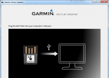
A program that allows you to update the firmware on your Garmin Vector device.